

The cars and trucks go whizzing past. They used to be able to stop and refuel, allowing the people inside a chance to get out and stretch their legs. Now the motorway exit and nobody stops and gets out. The megalithic tomb is largely unvisited and only rarely seen as the vehicles rush past. The motorway has changed the environment around the structure, but it still remains.
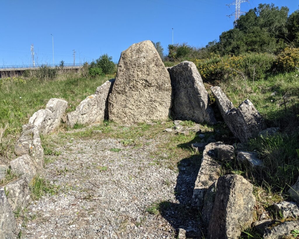


This is the third, and most recently built, anta (“dolmen”) in the Antas of Belas conjunction. It lies in a fold in the earth and therefore neither of the other two antas can be seen from here. It has a chamber made of 7 stones, approximately 4m long and 3.8m wide. The corridor, which points West because of the layout of the fold, was reconstructed without the original sockets being found. The anta was built during the transition from the 4th millennium into the 3rd, and then more intensely used in the first half of the 3rd millennium.1
The upright slabs of the chamber (the esteios or “orthostats”) are covered with ichnofossils, trace fossils of ancient animals, which seem to have been arranged intentionally, facing into the chamber, for either aesthetic or perhaps ritualistic purposes.2
The anta’s location next to a motorway is (obviously) a recent phenomenon, and it would have been a more peaceful location in pre-automobile times.

The Anta da Estria was declared a National Monument in 1910, as part of the Antas de Belas group of three.
Location
The anta is in the Lisbon region, in the municipality of Sintra. It’s in the parish of Queluz and Belas, very close to the town of Monte Abraão. It’s on a hillside above the A9 motorway, in an island formed by the connecting roads between the A9 and A16 motorways.
Access
Since the building of the A9 motorway, the Anta da Estria was extremely easy to reach, as it was incorporated into the surrounds of a lay-by with a filling station and snack bar. That was shut around 2015, and the exit to the lay-by has been closed. The only way to reach the anta is by walking across a pedestrian bridge. The walk is not very difficult, but the path on the “island” on the other side of the bridge has become horribly overgrown with brambles. The final gate to get into the area of the lay-by also has a rusted-shut door. It is possible to reach the anta by climbing through a hole that has been cut in the gate.


Signage
The only signs indicating the anta are in the closed car park of the lay-by along the A9 motorway.

Links
- Article (in English) from Wikipedia
- Entry (in English) in the Megalithic Portal
- 3D Model (no language) by Luís Câmara on Sketchfab
- Description (in Portuguese) from Archaeologist’s Portal of the Directorate-General of Cultural Heritage
- Designation (in Portuguese) as a National Monument by the Director-General of Cultural Heritage
- Detailed entry (in Portuguese) in the database of the Directorate-General of Cultural Heritage
Nearby
This is one of the three “Antas de Belas,” including also the Anta de Monte Abrãao (a short walk away) and the Anta da Pedra dos Mouros. The Anta de Agualva is also in the area, as is the Necrópole de Carenque.
Sources
- Rui Boaventura, and João Luís Cardoso. “Carlos Ribeiro (1813-1882) e as Antas de Belas: Um Contributo Para a História Da Ciência Em Portugal No Século XIX.” Estudos Arqueológicos de Oeiras, vol. 21, no. 21, Jan. 2014, pp. 35–80, www.researchgate.net/publication/289532409_Carlos_Ribeiro_1813-1882_e_as_antas_de_Belas_um_contributo_para_a_Historia_da_Ciencia_em_Portugal_no_seculo_XIX_-_Carlos_Ribeiro_1813-1882_and_the_dolmens_of_Belas_a_contribution_for_the_History_of_Sc. ↩︎
- Cardoso, João Luís, and Rui Boaventura. “The Megalithic Tombs in the Region of Belas (Sintra, Portugal) and Their Aesthetic Manifestations.” TRABAJOS de PREHISTORIA, vol. 68, no. 2, 2011, pp. 297–312, https://doi.org/10.3989/tp.2011.11071. ↩︎
- Roteiros Da Arqueologia Portuguesa 1: Lisboa e Arredores. Instituto Português do Património Cultural, Departamento de Arqueologia, 1986 ↩︎
Pingback:Anta do Monte Abraão - Prehistoric Portugal
Pingback:Anta de Agualva - Prehistoric Portugal
Pingback:Anta da Pedra dos Mouros - Prehistoric Portugal
Pingback:Necrópole de Carenque - Prehistoric Portugal