

Walk through the sunny forests on the hills above the Tejo River. Enjoy the birdsong and wildflowers. As you round a bend on the trail, marvel at the enormous stone slabs standing over 2m tall. They have been standing there for 5,000 years.


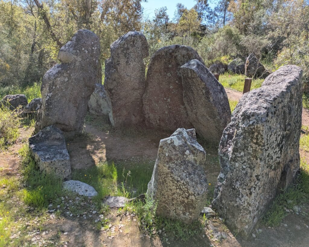

This anta (“dolmen” – megalithic chambered tomb) was built during the Late Neolithic/Chalcolithic period, about 3500-2200BC. It has an elongated polygonal chamber (3.3m long by 2.7m wide), formed by nine massive granite orthostats (one of which is missing). (“Penedo Gordo” can be translated as “fat stones.”) There is a medium length (3m) corridor formed by four uprights on each side, facing East.1
The anta was identified and first excavated by Francisco Pereira da Costa in 1868. It was fully excavated by Ana Leite da Cunha and João Luís Cardoso in the 1990s. Despite the anta having been disturbed, many stone artefacts (both chipped and polished) were found, as well as ceramic containers, and decorated schist and sandstone plaques.
Location
The anta is in the district of Portalegre, in the municipality of Gavião, the parish of Belver. It’s along a hiking trail (the PR1 short walking route), right beside the path.
Coordinates: 39.491854, -7.997264
Access
You can drive along small country roads, including dirt roads nearly all the way. The final 200m is best traveled on foot. The road is quite flat.
Signage
From the town of Belver, head towards the “Barragem” (dam) of Belver. There will be a sign to the anta just outside the village of Torre Fundeira.

From the village of Ortiga, there are no signs towards the anta until you are nearly there. Head towards the “Barragem” (dam) or the “Praia Fluvial” (river beach, next to the dam) and cross the dam. The road to the anta is the first dirt road heading north (left) after the dam.
The signs for the anta are along that dirt road, showing the anta and the PR1 walking route.


There’s an information sign in Portuguese at the anta:

The sign says:
A megalithic monument erected during the Neo-Chalcolithic period in this region of present-day Portuguese territory, the anta (the term by which dolmens are best known locally) has a burial chamber with an elongated polygonal plan, just over three metres long and almost three metres wide, made up of nine pillars. As for the access corridor to its interior, approximately three meters long, it consists of four supports on each side, and the covering slab has not been found, although elements of the primitive mound remain.
A. Martins
Links
- Entry (in English) in the Megalithic Portal
- Description (in Portuguese) from the town hall of Gavião
- Description (in Portuguese) of the PR1 walking route that features the anta from the parish of Gavião/Atalaia
- Description (in Portuguese) from Archaeologist’s Portal of Directorate-General of Cultural Heritage
- Designation (in Portuguese) as a Property of Public Interest by the Directorate-General of Cultural Heritage
- Detailed information (in Portuguese) in the database of the Directorate-General of Cultural Heritage
Nearby
The Anta da Foz do Rio Frio is about 9km away. There are also many rock carvings in the Mação area, as well as the museum in Mação.
Sources
- Cardoso, João & Cunha, Ana. (2003). A anta do Penedo Gordo (Belver, Gavião). Estudos Pré-Históricos. X-XI. 31-53. Accessed 3 May 2025 from https://www.researchgate.net/publication/265560936_A_anta_do_Penedo_Gordo_Belver_Gaviao ↩︎
Pingback:Anta da Foz do Rio Frio - Prehistoric Portugal