

Also known as: Cromeleque de Perdigões
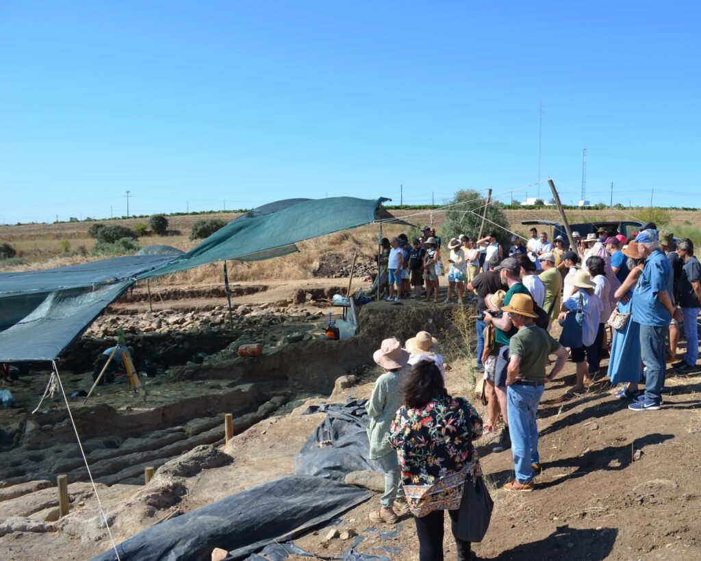
Below the flapping tarpaulins, archaeologists work, carefully excavating holes in the hard clay. There are many holes, forming a series of concentric circles. The team leader explains the site, using maps and illustrations. He points off to the East and explains how the enclosure opened up towards the rising sun, particularly the solstices. He speaks eloquently and passionately about this complex, bringing the visions of the ritual and other activities which were conducted here five thousand years ago.


This site is a Neolithic and Chalcolithic site made up of ditches surrounding a central enclosure made up of concentric circles of wooden poles. It dates from 3,400BC to 2,000BC.
Before the ditches were discovered, several menirs had been known from the site thus earning it the name of the “Cromeleque of Perdigões.” The menirs were scattered and there was no real possibility of reconstruction. In 1996, the wine estate that owned the land discovered more archaeological remnants and halted their expansion of vinyards. The excavation that followed was managed by ERA Arqueológia, a private archaeological organization, and led by archaeologist António Carlos Valera.
Archaeological excavations are ongoing, so the site is not open to the public. However, ERA Arqueológia holds various “open days” in which interested members of the public (as well as archaeologists and historians) are invited to a guided tour of the complex led by António Carlos Valera. The photos taken here are from one of those open days.
The complex is one of a number of ditch enclosures found in Portugal, but with a difference. There is little evidence of habitation (some huts were identified as from a later stage of occupation), but the site centres on a 20m-wide central enclosure of concentric circles of wooden poles. This timber circle is unique in Iberia. There were also funerary sites nearby, which may have coincided with the megalithic constructions.
Many artefacts have been discovered, showing a rich history of people traveling from far away to come to this site: ivory carvings from Africa, materials from other parts of Europe. A museum is being planned to showcase some of the artefacts, which would be available outside of the open days.
During the presentation, Dr. Valera shows us an illustration of how the central complex might have looked:

In addition to the illustration, a large “map” of the site is used to highlight specific areas.

After the demonstration, we are led to the Esporão Tower to see some of the artefacts discovered at the site, and to hear a presentation by Dr. Valera about the site and the plans to develop a “Route of Ceremonial Enclosures” featuring Perdigões and other ditch enclosures in the area.


Location
The Perdigões archaeological complex is a few kilometers outside of the town of Reguengos de Monseraz, in the eastern part of the Alentejo region, Évora district. It is located on land owned by the Esporão winery.
Access
The site is a working archaeological dig, managed by ERA Arqueologia. They have occasional “open days” for visitors, which are announced on their website and social media channels (Facebook, Instagram).
Signage
There is no public information posted about the site, and no signs pointing it out. If you want to visit, you will need to contact ERA Arqueologia.
Links
- Website (in English) of the site
- Description (in Portuguese) from ERA Arqueologia
- Film (in English) created for ERA Arqueologia/Perdigões by Raul Losada Film
- 3D video reconstructions (without language) of life in Perdigões by ERA Arqueologia
- Video about the central Timber Circle (in Portuguese with English subtitles) from ERA Arqueologia
- Video playlist (videos in Portuguese) from ERA Arqueologia
- Video about Portugal’s “Woodhenge” (in English) from Ancient Architects
- Article (in Portuguese) from Wikipedia
- Description (in English) from Herdade do Esporão winery
- Entry (in English) about the menires from the Megalithic Portal
- Description (in Portuguese) of the site (and cromeleque) from Archaeologist’s Portal of Directorate-General of Cultural Heritage
- Designation (in Portuguese) as a National Monument by the Directorate-General of Cultural Heritage
- Entry (in Portuguese) in the database of the Directorate-General of Cultural Heritage
- Entry for the menires
Nearby
The region is absolutely full of prehistoric sites. There are several individual menirs and antas close by. Perhaps the most important site nearby is the Cromeleque of Xerez, about 16km to the East of Reguengos de Monseraz.
References
- Taklim, Luis. “O Omphalos de Perdigôes,” National Geographic História: Pré-História Ibérica, 2023, www.nationalgeographic.pt/edicoes/especiais/revista-pre-historia-iberica-edicao-especial_4351. ↩︎
- Era Arqueológia . “Fossos de Perdigões,” Era Arqueológia, 2020, perdigoes.org/en/wp-content/uploads/2020/01/Fossos_imagem-de-entrada-e1580424291947.jpg. Accessed 11 June 2024. ↩︎
John, another fascinating post!
Thank you
Thank you! Perdigões is a poorly-known, but fascinating spot. Hopefully they will have more open days soon.